

A Fair World Begins with a Fair Map: The UN Adopts Equal Earth Projection
On September 4, 2026 the United Nations adopted Resolution A/80/L.104 #CorrectTheMap, with an overwhelming global consensus. The resolution recognizes the distortions inherent in the Mercator projection and encourages member states to use area-preserving maps, specifically referring to the Equal Earth projection.
The commonly used Mercator projection developed in the 16th century distorts the relative size of land masses by expanding those nearer the poles. For instance, it makes Greenland appear roughly the same size as Africa, even though Africa is about 14 times larger. Algeria illustrates this misconception: Africa’s largest country by size with a land mass of more than 2.38 M km2, its borders can encompass twelve European countries, including the UK, Spain, Greece, and Germany. In the Mercator projection, however, it looks only slightly larger than France.
The problem of distortions has long been recognized among cartographers—in 2018, the Equal Earth projection was developed by Bojan Šavrič, Bernhard Jenny und Tom Patterson. It is one of several maps that aim to better represent the relative size of equatorial and non-equatorial regions, with its curved edges revealing the spherical shape of the earth.
UN Adopts the Equal Earth Map
The UN General Assembly adopted the resolution with an overwhelming majority of 164 votes in favor, 6 abstentions and 1 vote against (United States of America), showing a rare moment of global consensus. The abstentions by Ukraine, Estonia, Georgia, Lithuania, Republic of Moldova, and Serbia, who voted in solidarity, were not based on the core issue of the resolution, the size distortions, but instead on the shade of color used for Crimea, which is occupied by Russia. The US was the only country to vote against the resolution, alleging that the UN’s decline is attributable to its debating 400-year-old maps, revealing both the US’s ignorance about the concerns of most of the UN’s member states and that country’s isolation within the international system.
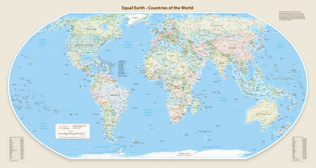

The Equal Earth Map. | Cartographer: Tom Patterson/Equal Earth | Public Domain
African Civil Society and Diplomatic Efforts Lead to UN Resolution
The adoption of the resolution “is the culmination of an African-led campaign“ waged jointly by civil society and continental diplomatic efforts—not only as a cartographic correction but as part of Africa’s global repositioning. Its journey began with two pan-African civil society organizations, Africa No Filter and Speak Up Africa, launching the #CorrectTheMap Initiative in 2024. According to these organizations, over 13,000 people signed the accompanying petition that called on the UN “to adopt the Equal Earth projection in their data, reports, and materials that include world maps.”
After the AU Commission endorsed the initiative in August 2025, the 9th Pan-African Congress, held in Lomé from December 8 to 12, 2025, advanced the #CorrectTheMap Initiative further on the continental agenda. Only two months later, the Assembly of Heads of State and Government of the African Union adopted the initiative during its 39th Ordinary Session through Decision Assembly/AU/Dec.959 (XXXIX) in February 2026. This decision elevated the initiative to a continental position and was followed by a campaign directed towards the UN General Assembly. Selma Malika Haddadi, deputy Chairperson of the African Union Commission, situated the endorsement within Africa’s broader effort to fight the marginalization of the African continent on the global stage.
The campaign was a key part of the AU’s larger reparations and justice agenda under the AU’s 2025 theme of the year and centered around three elements; the material misrepresentation of Africa, its political implications, and broader support for adopting more accurate equal-area projections. Among its objectives is to change the maps used for education, media, and institutions towards equal-areas projections, to raise awareness for the effects of cartographic representations on perceptions of Africa and the Global South—as Togo’s Foreign Minister Dussey argues, “a fair map does not change the geography of the world, it changes how we see the world”—and to strengthen Africa’s dignity, visibility, and strategic positioning on the global stage.
Togo, as a member state of the African Union, brought the resolution before the General Assembly. Multilateral diplomatic efforts by Togo in London, New York, and Geneva, supported by the AU’s regional offices in Washington, Brussels, Geneva, Beijing, and Cairo, helped secure broad support for the vote. On the evening of the vote, Togo briefed the African Group and called for collective mobilization. In introducing the text on behalf of the African group, Foreign Minister Robert Dussey explicitly stated the goal: “to promote projections that better preserve the true proportions of continents” and to recognize that “every region of the world deserves to be represented accurately and with dignity.”
The successful adoption of the resolution goes back to the “unity and collective mobilization” of AU Member States and the African Group in New York. It is particularly important because “Africa must be represented as it truly is: in its true dimensions and in its rightful place in the world,” as highlighted by AU Commission Chairperson Mahmoud Ali Youssouf.
Why Maps Are Important for Representation: Agency through Expertise
By framing the debate over the world map at the UN as a “scientific discussion,” Togo’s Foreign Minister Robert Dussey enacted a moment of agency through expertise, shifting the debate onto terrain where scientific authority could be mobilized. Maps are technical attempts to represent a three-dimensional Earth on a two-dimensional surface, and every projection necessarily involves choices and compromises. The 16th-century Mercator projection (what we know as the current world map) was designed to solve a particular practical problem: navigation. Its preservation of angles made it especially useful for sailors to chart courses across the globe. As a result, distortions in land areas were a deliberate trade-off, prioritizing navigational accuracy over accurate representation of land size.
The question is not whether Mercator is “wrong,” but rather: what happens when a projection designed for navigation becomes the dominant representation of the world? As Professor Carlos Lopes of the Nelson Mandela School of Public Governance argues, a specialized navigational projection has become the “standard portrait of the world,” shaping how Africa is perceived in classrooms and beyond. Such perceptions can shape how young people understand their own place in the world, influencing their sense of identity and agency.[1] Critics of the map hold that the map was “made by and for Europe” and that the misleading size representation of different countries reinforces Western imperialist stereotypes that undermine fairness and accuracy.
The African Union’s championing of the resolution demonstrates how scientific expertise can become a form of diplomatic agency. Rather than simply demanding that Africa “look bigger,” it challenges which representations of the world are treated as authoritative. This raises a broader question: how and when does scientific evidence become diplomatic authority? The UN debate suggests that this occurs when scientific expertise is translated into a claim about institutional practice, allowing states to challenge established forms of knowledge and exercise agency within international institutions.
The Next Steps: Adopting Equal Earth Across the Globe
Although the UN decision on September 4th was an important milestone, a collective effort will be required to replace the Mercator maps used across the globe. The time it will take for the Equal Earth map to be adopted depends on member states’ willingness and capacity to do so. Those involved in the campaign know that “now the real work begins” and urge organizations like the World Bank and the UN to swiftly adopt the Equal Earth map. France, a co-sponsor of the resolution, announced that it planned to abandon the Mercator map in favor of more accurate representations of actual surface areas.
The adoption of the resolution shows how civil society initiatives can become issues on the global agenda, moving through regional organizations to the General Assembly.
Germany
In the days after the vote, the German Foreign Minister, the Foreign Office, and Germany’s Representations at the UN remained surprisingly silent—which stands out compared to the extensive media coverage in many African or Asian countries. Even though Germany voted in favor of the resolution; no press releases or social media posts could be found in the following days. Only the Federal Ministry for International Cooperation (BMZ) posted on Instagram, announcing that they would adopt the map. Germany should swiftly adopt the map across public administrations and in schools, thereby not only recognizing the factual distortions but also the postcolonial hierarchies embedded in the maps—taking small steps towards a fairer Earth.
The Equal Earth map can be downloaded and ordered for free here.
[1] Professor Lopes argues: “Children learn from these maps. They grow up thinking Africa is modest in size when, in reality, it’s gigantic: larger than the U.S., China, India, Japan, and much of Europe combined. Perception translates into confidence, and confidence into action. So yes, inaccurate maps undermine the capacity for action.”
Series
Related Posts
Tags

Sophia Birchinger
Latest posts by Sophia Birchinger (see all)
Sarah McKee
Latest posts by Sarah McKee (see all)

Frederik Schissler
Latest posts by Frederik Schissler (see all)

Myriel Julie Mathez
Latest posts by Myriel Julie Mathez (see all)
- A Fair World Begins with a Fair Map: The UN Adopts Equal Earth Projection - 16. September 2026